
Sydney air quality map
Live air pollution map of Sydney • 1.8M Followers • 06:00, Jul 18 Local time


Stations
Clean Air Facilities
Contributors
Government
1Diplomatic
0Non-profit
0Education
0Corporate
0Healthcare
0Hospitality
0Individual
41Top contributors in Sydney
Who is sharing outdoor air quality data in Sydney?
Featured station
Discover some of the best station installation in Sydney
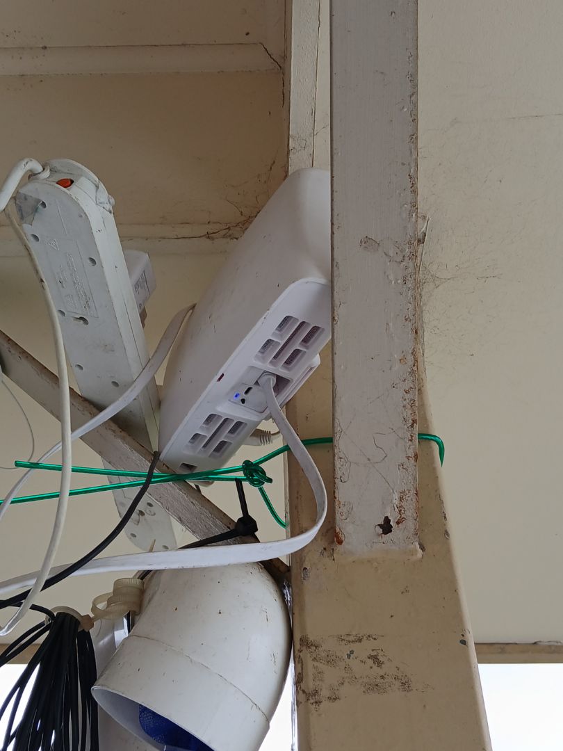
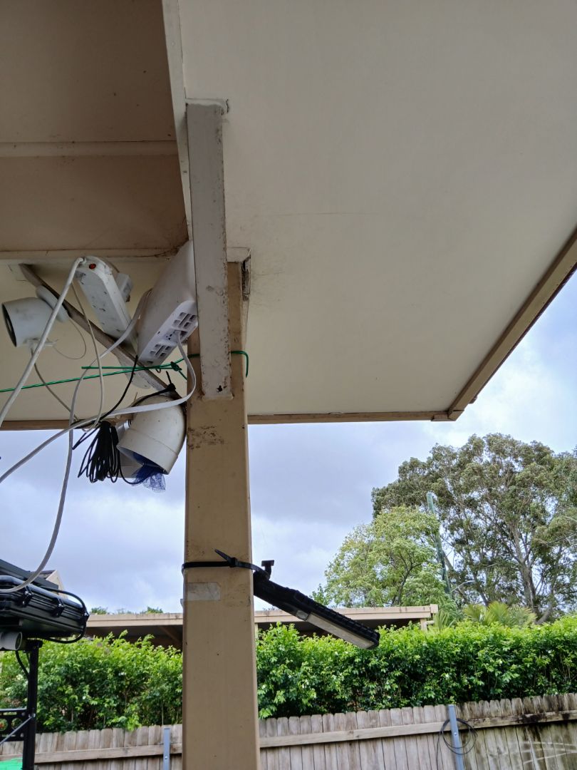
Station gallery

Northmead, Sydney
34
Newest stations deployed in Sydney
AQI⁺ station rankingNewest stations


Learn more about global air quality


Learn more about air pollution in Sydney
How bad is the air quality in Sydney?
In general, air quality in Australia is relatively healthy by global standards – however, there is room for improvement, and particularly a number of areas in Australia are facing health risks from air pollution in relation to increasing occurrences of bush fires. Sydney air quality is no exception to this, as the city experiences year-round exposure to a range of air pollutants, in addition to more extreme, short-term air pollution events such as wildfires and dust storms.
The main pollutants of concern in Sydney are particulate matter and ozone, both of which are reported as often exceeding national standards.1 However, it is worth noting that Australia air quality standards are among the strictest in the world for fine particulate matter (PM2.5), with an annual average target of 8 micrograms per cubic meter (μg/m3), which is lower than the standards of the World Health Organisation (10 μg/m3), the United States (12 μg/m3) and the European Union (25 μg/m3).2 Despite these target limits, the World Health Organisation emphasises that exposure to any amount of PM2.5 can contribute to negative health impacts. Different studies on the health impacts of air pollution in Sydney estimate that residents’ exposure to air pollutants in the city, contribute towards 1.6-2.9% of total annual fatalities.3
In 2019, Sydney’s annual average PM2.5 concentration was 10.1 μg/m3, exceeding both the Australian and WHO target limit. In broader Australian context, this ranked as the 15th most polluted city for annual PM2.5 levels in Australia out of 95 included cities in IQAir’s 2019 World Air Quality Report. In contrast, Armidale in New South Wales ranked as Australia’s most polluted city (annual average 23 μg/m3), and the capital, Canberra air pollution ranked 3rd (annual average 15 μg/m3). Sydney’s 2019 annual average represents an increase from its 2018 (7.6 μg/m3) and 2017 (7.1 μg/m3) levels, which may be linked to an increase in wildfires experienced in the New South Wales region during the winter of 2019 to 2020.4
Real-time air quality information, health advice and a 7-day Sydney air quality forecast are provided at the top of this page, along with a live Sydney air quality map, which also indicates current wildfire information.
What are the main sources of air pollution in Sydney?
In addition to fires and other natural pollution events, major year-round sources of Sydney air pollution include motor vehicle exhausts (particularly for nitrogen dioxide and PM2.5), and power stations as a source of PM2.5. Australia’s fuel and vehicle emission standards are found to lag behind other developed nations; making these standards more strict could offer one opportunity to decrease harmful emissions from transport.3
What is causing smoke in Sydney?
The majority of Sydney’s extreme short-term air pollution events are related to wildfires or hazard reduction burning.3 Bushfires are nothing new for Sydney; Australia has an established “fire season”, although the 2019 fires were particularly severe. This was due to a particularly dry and hot spell which may be linked to the broader trend of increasing global temperatures as part of climate change.5 Bush fires are often started naturally by a lightning strike or accidentally through a human-made spark, while others are started deliberately, either as part of planned hazard reduction strategies or maliciously, through arson.5 An additional natural source of extreme air pollution events in Sydney is also occasional dust storms, originating in the dry inland regions of the country, most often occurring during spring.3
Why is Sydney experiencing smoke?
While the wildfire season was particularly bad across numerous states in Australia during August 2019 to February 2020, and became colloquially known as the “Black summer”, Sydney’s state of New South Wales air quality was the worst affected.6,7 In addition to air quality impacts, the fires were estimated to destroy 2,439 homes in New South Wales, and to have burned at least 5.3 million hectares (6.7% of the state).8 Nationwide, the health impacts of smoke from these wildfires is estimated to have led to 445 premature deaths from respiratory conditions, and put a further 4,000 people in hospital.9 In Sydney, the fires led to the city experiencing its worst ever air quality on record, with PM2.5 levels reaching nearly 400 μg/m3 in December 2019, exceeding the WHO’s guideline by almost 40 times.10 Furthermore, by 25 December 2019, the city had experienced a continuously “hazardous” level of air quality for at least 30 days, indicating a long period of unrelenting exposure to harmful smoke.11
Is Sydney threatened by fire?
Australia is likely to continue its annual pattern of seasonal wildfires in the future, which may again affect Sydney with smoke and air quality impacts. Following the unprecedented level of wildfire activity during 2019-2020, however, experts suggest that as a consequence of the enormous loss of “fuel” in the form of trees, forest, and dead plant material among other factors, the annual wildfires may not occur in such an extreme form in the subsequent three to five years.6
What is Sydney doing to reduce air pollution?
Australia’s air quality management system is governed at both the national and local level. National air quality governance includes the establishment of country-wide air quality standards, called the National Environmental Protection Measure for Ambient Air (NEPM) which were implemented in 1998. The Air NEPM sets standard targets for 7 key air pollutants, including carbon monoxide, lead, nitrogen dioxide, ozone, particulate matter (PM2.5 and PM10), and sulphur dioxide.1 Local governments, such as in New South Wales, are responsible to try to ensure their region achieves these national air quality objectives.
At a local level, the New South Wales government also runs a number of air quality management initiatives. Their Department of Planning, Industry and Environment (DPIE) operates a network of governmental air quality monitors around the Sydney region, which monitor 6 different ‘criteria air pollutants’, including ozone (O3), nitrogen dioxide (NO2), carbon monoxide (CO), sulphur dioxide (SO2), particulate matter (including both PM2.5 and PM10), and visibility. Visibility is an additional indicator of air quality that the NSW government reports on and sets a standard target for beyond national obligations. Visibility can serve as an additional indicator of levels of smoke.12
Sydney and the NSW government follow the national Australian Air Quality Index system to report a Sydney Air Quality Index (AQI) figure. The national AQI system adopts a scale of 0-200+, where 0-33 represents ‘Very Good’ air quality, and the top end of 200+ represents ‘Hazardous’ air quality. The Sydney AQI numbers are calculated in the same way as nationwide, whereby ‘100’ represents the maximum allowance of the relevant air quality target; 200+ therefore represents an exceedance of at least 100%.
While the New South Wales government had been developing a standalone Clean Air Strategy for 5 years since 2016, involving several public consultations and a clean air summit in Sydney in 2017, this commitment was dropped in June 2020. The government justified this by explaining that air quality considerations would be absorbed into other policy areas, such as environment and industry policies.13 However, communities affected by pollution in the region, along with environmental organisations argue that without an overarching policy to co-ordinate local air quality management, air pollution improvements may be inadequately focused or prioritised.
+ Article resources
[1] Australian Government. “National Clean Air Agreement”, Australian Government website, December, 2015.
[2] Australian Government. “National air quality standards: Ambient air quality (2016)”. Australia Government State of the Environment website, 2016.
[3] Clare Paton-Walsh et al. “A Clean Air Plan for Sydney: An Overview of the Special Issue on Air Quality in New South Wales”. Atmosphere 10, Issue 12 (December 4, 2019), 774. DOI: 10.3390/atmos10120774
[4] IQAir. “2019 World Air Quality Report”. IQAir website, March 18, 2020.
[5] BBC. “How did Australia fires start and what is being done? A very simple guide.” BBC website, January 7, 2020.
[6] Kevin Tolhurst. “It’s 12 months since the last bushfire season began, but don’t expect the same this year”. The Conversation, June 10, 2020.
[7] Justine Calma. “What you need to know about the Australia bushfires”. The Verge, Feburary 13, 2020.
[8] Lisa Richards, Nigel Brew. “2019-20 Australian bushfires – frequently asked questions: a quick guide”. Parliament of Australia website, March 12, 2020.
[9] Calla Wahlquist. “Australia’s summer bushfire smoke killed 445 and put thousands in hospital, inquiry hears”. The Guardian, May 26, 2020.
[10] Pippa Neill. “The horror of the Australian bushfires and air pollution”. Air Quality News, January 6, 2020.
[11] Adam Morton. “Yes, Australia has always had bushfires: but 2019 is like nothing we’ve seen before”. The Guardian, December 24, 2019.
[12] NSW Government. “Standards and goals for measuring air pollution”. New South Wales government website, n.d.
[13] Lisa Cox. “NSW government abandons plan for air pollution policy after five years of planning.” The Guardian, June 5, 2020.
Where is the cleanest air quality in Sydney?
- Randwick0
- Georges River Road1
- Weeroona Road 32
- 43 Blackbutt Cir3
- 5 Byrne St3
- Gymea Bay 13
- Jannali4
- Barnes Road5
- 63 Gould Ave6
- Liverpool6
- St Marys6
- 24-36 Flora St7
- Rofe Park7
- Glenton Street8
- Miles Crescent11
- 70-112 Queens Parade E12
- George Street 212
- Rozelle14
- Campbelltown West16
- Lidcombe NSW Australia16
- Threlfall Street16
- Wood Street18
- Muston Street20
- Beacon Hill22
- Grandview Street22
- Parramatta North22
- West Pymble23
- 20-2 New St W24
- The Esplanade24
- 175-169 Liverpool St26
- 47-19 Wharf Rd26
- 72 Carlingford Rd27
- Bringelly27
- Deakin Place27
- Rouse Hill28
- Bradford Street29
- Evans Street31
- Woollahra33
- Bradfield Highway34
- Northmead34
- Queens Park, Carrington Road37
- Weeroona Rd41
- Cook And Phillip45
- Richmond46
- Earlwood53
- Oakdale57
- Muir Road63


