
Air quality near Oxford High St, Oxford
Air quality index (AQI⁺) and PM2.5 air pollution near Oxford High St, Oxford • 4.8K Followers
44
US AQI⁺Good

Main pollutant:
PM2.5
7.9 µg/m³
30°
4 km/h
49 %
Hourly forecast
Oxford High St, Oxford air quality index (AQI⁺) forecast
Daily forecast
Oxford High St, Oxford air quality index (AQI⁺) forecast
| Today | 50 | 34° 18° | 16 km/h | 57% | |
| Wed | 61 | 33° 21° | 13 km/h | 61% | |
| Thu | 55 | 36° 19° | 20 km/h | 56% |
Air pollutants
What is the current air quality near Oxford High St?
PM2.5 concentration is currently 1.6 times the World Health Organization annual PM2.5 guideline value.
Health recommendations
Enjoy outdoor activities |
Open your windows to bring clean, fresh air indoors Get a monitor |
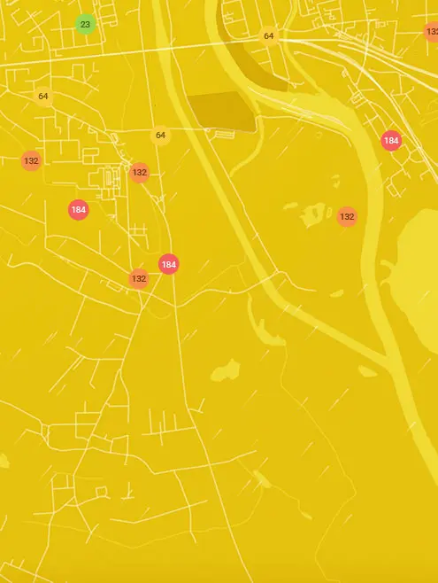
Real-time Oxford High St, Oxford air pollution map
Pollen
What is the pollen count in Oxford High St today?
Index

High
Tree None | 0% |
Grass High | 75% |
Weed None | 0% |
Source:
Open-Meteo.comPollen
What is the pollen count in Oxford High St today?
Index
High
Tree None | 0% |
Grass High | 75% |
Weed None | 0% |
Source:
Open-Meteo.comHistoric air quality near Oxford High St
History
Historic air quality graph for Oxford High St
Measure your own air quality
Get a monitor and contribute air quality data in your city.
Most polluted locations near Oxford High St, Oxford
Worldwide AQI⁺ rankingStation ranking
Real-time Oxford High St AQI⁺ station ranking
Get comprehensive data about air quality in Oxford High St, Oxford


Download our Air Quality App
Learn more about global air quality


Where is the cleanest air quality in Oxford?
- Crabtree Road14
- Childrey Way28
- St John's College Sports31
- Hamilton Road33
- Stone Meadow33
- 52 Whitehouse Rd36
- St. Ebbes Primary School 236
- Charlbury Road37
- Kingston Road37
- 70 Hayfield Road39
- St Lukes' Road39
- Staunton Road39
- Cheney School40
- Plantation Road44
- Belvedere Road46
- Old Road46
- Chalfont Road52
- Oxford St Ebbes53


