

Hourly forecast
Edson-Smith Greenstone Country, El Dorado County air quality index (AQI⁺) forecast
Daily forecast
Edson-Smith Greenstone Country, El Dorado County air quality index (AQI⁺) forecast
| Today | 23 | 30° 15° | 12 km/h | 42% | |
| Thu | 40 | 30° 14° | 12 km/h | 40% | |
| Fri | 42 | 32° 12° | 12 km/h | 32% |
Air pollutants
What is the current air quality near Edson-Smith Greenstone Country?
PM2.5 concentration currently meets the WHO annual PM2.5 guideline.
Health recommendations
Enjoy outdoor activities |
Open your windows to bring clean, fresh air indoors Get a monitor |
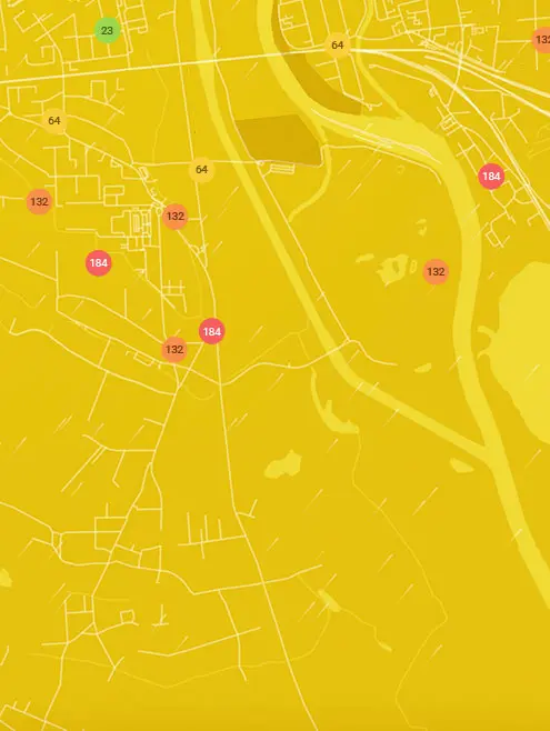
Real-time Edson-Smith Greenstone Country, El Dorado County air pollution map
Pollen
What is the pollen count in Edson-Smith Greenstone Country today?
Index

Low
Tree Low | 25% |
Grass Low | 25% |
Weed Low | 25% |
Source:
wetter.comPollen
What is the pollen count in Edson-Smith Greenstone Country today?
Index
Low
Tree Low | 25% |
Grass Low | 25% |
Weed Low | 25% |
Source:
wetter.comHistoric air quality near Edson-Smith Greenstone Country
History
Historic air quality graph for Edson-Smith Greenstone Country
Measure your own air quality
Get a monitor and contribute air quality data in your city.
Most polluted locations near Edson-Smith Greenstone Country, El Dorado County
Worldwide AQI⁺ rankingStation ranking
Real-time Edson-Smith Greenstone Country AQI⁺ station ranking
Get comprehensive data about air quality in Edson-Smith Greenstone Country, El Dorado County


Download our Air Quality App
Learn more about global air quality


Where is the cleanest air quality in El Dorado County?
- Early Dawn Trail2
- EDCAQMD - Mount Aukum Road4
- EDCAQMD - Washoe Meadows4
- Koru Street4
- Edson-Smith Greenstone Country5
- Brandywine Farms6
- CARB-Fresh Pond7
- Chili Bar Lane7
- Greenwood Station7
- Garden Park Drive9
- Nez Perce Drive9
- Omaha Street9
- Four Ring Road10
- Lotus Station10
- Ojibwa Street10
- EDCAQMD - Sly Park Road11
- EDCAQMD Audubon Hills11
- Hank Monk Avenue11
- Hope Mountain Road11
- 3204-3202 Scott Valley Rd12
- EDCAQMD - Luneman Road12
- Rubicon Bay12
- Highlands Drive13
- Red Robin Road13
- Reservation Road13
- Speckled Road13
- CARB Log Cabin Lane14
- Cold Creek Trail14
- EDCAQMD - Fallen Leaf14
- McManus14
- Retreat Lane14
- Wagon Train Trail14
- Wasatch Road14
- Arrowbee Drive15
- Susquehana Drive15
- Caldor Road16
- EDCAQMD - Garden Valley Road16
- Gentian Circle16
- Osage Circle16
- 8799 Riverwood Drive17
- EDCAQMD - Omo Ranch Road17
- EDCAQMD Otter Creek Elementary17
- Ken Derek Lane17
- Moon Lake Drive17
- Red Bud Lane17
- 4532 8 Mile Road18
- Diana Street18
- Forebay Bridge18
- Rancho del Sol18
- 4000 Luneman Road19
- Bodega Way20
- Gondola Upper Lift House20
- 2937-2923 Jacquier Rd21
- High Hill Road21
- EDCAQMD - Latrobe22
- Kanaka Valley22
- Pyramid Circle23
- Chaparral Drive31
- CARB - Oak Ridge Circle34


