

Hourly forecast
241-223 St Albans St N, Minneapolis air quality index (AQI⁺) forecast
Daily forecast
241-223 St Albans St N, Minneapolis air quality index (AQI⁺) forecast
| Today | 46 | 32° 21° | 11 km/h | 66% | |
| Fri | 59 | 27° 20° | 20 km/h | 72% | |
| Sat | 61 | 90% | 25° 20° | 17 km/h | 78% |
Air pollutants
What is the current air quality near 241-223 St Albans St N?
PM2.5 concentration is currently 1.4 times the World Health Organization annual PM2.5 guideline value.
Health recommendations
Enjoy outdoor activities |
Open your windows to bring clean, fresh air indoors Get a monitor |
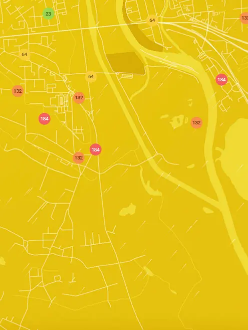
Real-time 241-223 St Albans St N, Minneapolis air pollution map
Pollen
What is the pollen count in 241-223 St Albans St N today?
Index

High
Tree None | 0% |
Grass Moderate | 50% |
Weed High | 75% |
Source:
wetter.comPollen
What is the pollen count in 241-223 St Albans St N today?
Index
High
Tree None | 0% |
Grass Moderate | 50% |
Weed High | 75% |
Source:
wetter.comHistoric air quality near 241-223 St Albans St N
History
Historic air quality graph for 241-223 St Albans St N
Measure your own air quality
Get a monitor and contribute air quality data in your city.
Most polluted locations near 241-223 St Albans St N, Minneapolis
Worldwide AQI⁺ rankingStation ranking
Real-time 241-223 St Albans St N AQI⁺ station ranking
City ranking
Real-time USA AQI⁺ city ranking
Get comprehensive data about air quality in 241-223 St Albans St N, Minneapolis


Download our Air Quality App
Learn more about global air quality


Where is the cleanest air quality in Minneapolis?
- Northeast Minneapolis station8
- 2nd St NE & 23rd Ave NE9
- City of Minneapolis Community Air Monitoring Project 1910
- Bancroft13
- City of Minneapolis Community Air Monitoring Project 814
- Minnehaha Creek/Lake Harriet21
- City of Minneapolis Community Air Monitoring Project 924
- Logan Park26
- Windom27
- City of Minneapolis Community Air Monitoring Project 7728
- Harrison29
- Minnehaha30
- 12th Avenue31
- 1800-1820 Franklin Ave SE31
- 5100-5198 16th Ave S31
- City of Minneapolis community air monitoring project 3331
- 104 E 56th St32
- 12 E 55th St33
- 2821 W 44th St33
- 3301-3345 E 36th St33
- City of Minneapolis Community Air Monitoring Project 733
- 2798-2700 E 22nd St34
- 3100-3198 29th Ave S34
- 4928 38th Ave S34
- 5050-5086 47th Ave S34
- 5399-5301 Pleasant Ave34
- 2301-2343 E 41st St37
- 46th St E & 3rd Ave S37
- 1801-1809 E 27th St38
- 241-223 St Albans St N38
- Linden Hills38
- 910-900 E 32nd St39
- Chowen Triangle Station39
- Elliot Park39
- 1264-1322 23rd Ave NE40
- 462-440 Central Ave W41
- Alie Micka41
- 1026-1032 27th Ave SE42
- 1211-1153 29th Ave NE42
- 2522 County Rd 2342
- 26th Ave NE42
- 36ish & Hiawatha42
- 1216-1294 Lakeview Ave S43
- 1299-1251 N 29th Ave43
- 1299-1251 W 27th St43
- 1500 7th St. S43
- 164-198 1st Ave NE43
- 610 W 29th St43
- 1699-1601 10th Ave S44
- 550-598 W 27th St44
- 699-649 W 41st St44
- 98-70 8th Ave NE44
- Minneapolis - Bottin44
- NE 36th Ave44
- 2199-2183 Douglas Ave46
- 2399-2305 Irving Ave S46
- 3300-3398 County Rd 15246
- Minneapolis - Near R46
- Columbia Park (Backyard)47
- 2650-2698 N 16th Ave49
- 2600-2698 36th Ave N51
- Minneapolis - East P51
- 900-910 N 42nd Ave52
- 3758 Emerson Ave N53
- East Isles53
- 4858 Dupont Ave N54
- 5159 N Humboldt Ave54
- Minneapolis - Lowry 54
- Minneapolis - Pacifi54


