

Hourly forecast
Diablo Helipad, Whatcom County air quality index (AQI⁺) forecast
Daily forecast
|
Diablo Helipad, Whatcom County air quality index (AQI⁺) forecast
| Today | 17 | 18° 12° | 22 km/h | 77% | |
| Mon | 36 | 18° 13° | 22 km/h | 78% | |
| Tue | 29 | 18° 14° | 8 km/h | 88% |
Air pollutants
What is the current air quality near Diablo Helipad?
PM2.5 concentration currently meets the WHO annual PM2.5 guideline.
Health recommendations
Enjoy outdoor activities |
Open your windows to bring clean, fresh air indoors Get a monitor |
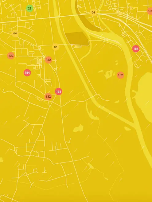
Real-time Diablo Helipad, Whatcom County air pollution map
Pollen
What is the pollen count in Diablo Helipad today?
Index

Moderate
Tree None | 0% |
Grass Low | 25% |
Weed Moderate | 50% |
Source:
wetter.comPollen
What is the pollen count in Diablo Helipad today?
Index
Moderate
Tree None | 0% |
Grass Low | 25% |
Weed Moderate | 50% |
Source:
wetter.comHistoric air quality near Diablo Helipad
History
Historic air quality graph for Diablo Helipad
6 AQI⁺ US
Good
00:00–01:00 Jun 28
AQI⁺ US
Measure your own air quality
Get a monitor and contribute air quality data in your city.
Most polluted locations near Diablo Helipad, Whatcom County
Worldwide AQI⁺ rankingStation ranking
Real-time Diablo Helipad AQI⁺ station ranking
Get comprehensive data about air quality in Diablo Helipad, Whatcom County


Download our Air Quality App
Learn more about global air quality


Where is the cleanest air quality in Whatcom County?
- North Shore Road1
- NWCAA - MBSA - Pan Hut3
- Thornton Road3
- Diablo Helipad6
- Matia View Drive6
- 4962-5098 Patton Rd7
- North Cascades Environmental Learning Center7
- North Springfield Court7
- 5018-5056 Wahl Rd8
- Sand Road8
- Hillspring Road9
- Island View9
- West Laurel Road9
- 2818-2890 Stein Hill Ln10
- Custer School Road10
- Mayne Lane 210
- Nulle Woods Court10
- East Hemmi Road11
- Loomis Trail Road station11
- East Badger Road-NWCAA - Nooksack Valley High School13
- Custer-Loomis18
- Chuckanut Point Road33
- Newhalem Street37


