

Air quality near Bakersfield - Golden State Highway, Bakersfield
Air quality index (AQI⁺) and PM2.5 air pollution near Bakersfield - Golden State Highway, Bakersfield • 1.3K Followers • 08:00, Jun 01
53
US AQI⁺Moderate

Main pollutant:
PM2.5
10 µg/m³
24°
6 km/h
39 %
Hourly forecast
Bakersfield - Golden State Highway, Bakersfield air quality index (AQI⁺) forecast
Daily forecast
Bakersfield - Golden State Highway, Bakersfield air quality index (AQI⁺) forecast
| Today | 57 | 36° 20° | 22 km/h | 29% | |
| Tue | 64 | 36° 21° | 22 km/h | 24% | |
| Wed | 65 | 38° 19° | 26 km/h | 15% |
Air pollutants
What is the current air quality near Bakersfield - Golden State Highway?
PM2.5 concentration is currently 2 times the World Health Organization annual PM2.5 guideline value.
Health recommendations
Sensitive groups should reduce outdoor exercise |
Close your windows to avoid dirty outdoor air Get a monitor |
Sensitive groups should wear a mask outdoors Get a mask |
Sensitive groups should run an air purifier Get an air purifier |
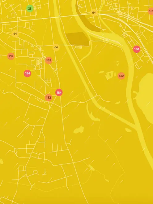
Real-time Bakersfield - Golden State Highway, Bakersfield air pollution map
Pollen
What is the pollen count in Bakersfield - Golden State Highway today?
Index

Moderate
Tree Low | 25% |
Grass Low | 25% |
Weed Moderate | 50% |
Source:
wetter.comPollen
What is the pollen count in Bakersfield - Golden State Highway today?
Index
Moderate
Tree Low | 25% |
Grass Low | 25% |
Weed Moderate | 50% |
Source:
wetter.comHistoric air quality near Bakersfield - Golden State Highway
History
Historic air quality graph for Bakersfield - Golden State Highway
Measure your own air quality
Get a monitor and contribute air quality data in your city.
Most polluted locations near Bakersfield - Golden State Highway, Bakersfield
Worldwide AQI⁺ rankingStation ranking


