

Air quality near Downtown Sacramento - T Street, Sacramento
Air quality index (AQI⁺) and PM2.5 air pollution near Downtown Sacramento - T Street, Sacramento • 46.7K Followers • 08:00, Jun 01
51
US AQI⁺Moderate

Main pollutant:
PM2.5
9.1 µg/m³
26°
5 km/h
40 %
Hourly forecast
Downtown Sacramento - T Street, Sacramento air quality index (AQI⁺) forecast
Daily forecast
Downtown Sacramento - T Street, Sacramento air quality index (AQI⁺) forecast
| Today | 55 | 34° 17° | 10 km/h | 36% | |
| Tue | 63 | 34° 15° | 20 km/h | 37% | |
| Wed | 63 | 35° 15° | 25 km/h | 35% |
Air pollutants
What is the current air quality near Downtown Sacramento - T Street?
PM2.5 concentration is currently 1.8 times the World Health Organization annual PM2.5 guideline value.
Health recommendations
Sensitive groups should reduce outdoor exercise |
Close your windows to avoid dirty outdoor air Get a monitor |
Sensitive groups should wear a mask outdoors Get a mask |
Sensitive groups should run an air purifier Discover Atem car |
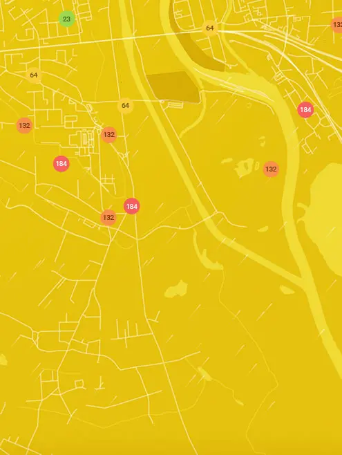
Real-time Downtown Sacramento - T Street, Sacramento air pollution map
Pollen
What is the pollen count in Downtown Sacramento - T Street today?
Index

High
Tree Low | 25% |
Grass High | 75% |
Weed Moderate | 50% |
Source:
wetter.comPollen
What is the pollen count in Downtown Sacramento - T Street today?
Index
High
Tree Low | 25% |
Grass High | 75% |
Weed Moderate | 50% |
Source:
wetter.comHistoric air quality near Downtown Sacramento - T Street
History
Historic air quality graph for Downtown Sacramento - T Street
Measure your own air quality
Get a monitor and contribute air quality data in your city.
Most polluted locations near Downtown Sacramento - T Street, Sacramento
Worldwide AQI⁺ rankingStation ranking
Real-time Downtown Sacramento - T Street AQI⁺ station ranking
City ranking
Real-time USA AQI⁺ city ranking
Get comprehensive data about air quality in Downtown Sacramento - T Street, Sacramento


Download our Air Quality App
Learn more about global air quality


Where is the cleanest air quality in Sacramento?
- Brickyard Drive14
- Sacramento station17
- South Natomas17
- East Sacramento18
- Kipping Way20
- River Isle Way21
- Santa Ynez sensor21
- 6 Tash Ct23
- City Hall Complex23
- Valley Hi / North Laguna 223
- North Sacramento24
- 14th Street & C Street25
- 57th Street28
- 9 Tash Ct28
- FourSeasons28
- Natomas Park28
- Perazul Circle28
- 312 Main AVE31
- Arcade and Diggs Park31
- Robla School31
- Virginia Way31
- 2-16 Tash Ct32
- 5724 Lonsdale Drive32
- 7630-7684 Beth St32
- Alhambra Triangle32
- Hughes Stadium32
- Lamberton Cir32
- Morley Way32
- S. Natomas32
- Southwestern Sacramento Station32
- Witter Ranch32
- 1904-1800 Volti Way33
- 2 Tash Ct33
- Belle Cooledge Park33
- 13th & T Street34
- May Street34
- Valletta Way34
- 629 Grand Avenue35
- Myrtle Vista35
- Richmond Grove 3 station35
- Rosebriar Court35
- 1014 Robertson Way36
- 2800-3268 36th Ave36
- 3343-3301 Western Ave36
- 52nd Street36
- Colonial Heights - 56th St36
- Dorothy Hill St36
- Grangers Dairy Drive36
- Midtown Solons36
- Del Paso Heights37
- East Road37
- 16th Ave 19th Avenue Alley38
- 672-722 Naruth Way38
- Bell Avenue School38
- Benicia Hall39
- Bercut Dr39
- Forney Way39
- Mc Kinley Boulevard39
- Willow Creek39
- 3735-3731 Stockton Blvd40
- Med Center41
- Tschannen Science Complex42
- Old Sacramento46
- Downtown Sacramento - T Street51
- Southeastern Sacramento 251
- 58th Street, East Sacramento52
- 48th Street53
- Capstan Way53
- 88th Street55


