

Air quality near Lower Woods Trail Northeast, Bradley County
Air quality index (AQI⁺) and PM2.5 air pollution near Lower Woods Trail Northeast, Bradley County • 1.5K Followers • 05:00, Jun 06 Local time
Data source: PurpleAir
59
US AQI⁺Moderate

Main pollutant:
PM2.5
13.5 µg/m³
18°
6 km/h
88 %
Data source: PurpleAir
Hourly forecast
Lower Woods Trail Northeast, Bradley County air quality index (AQI⁺) forecast
Daily forecast
Lower Woods Trail Northeast, Bradley County air quality index (AQI⁺) forecast
| Today | 60 | 28° 17° | 13 km/h | 65% | |
| Sun | 60 | 28° 20° | 16 km/h | 80% | |
| Mon | 60 | 21° 20° | 10 km/h | 97% |
Air pollutants
What is the current air quality near Lower Woods Trail Northeast?
PM2.5 concentration is currently 2.7 times the World Health Organization annual PM2.5 guideline value.
Health recommendations
Sensitive groups should reduce outdoor exercise |
Close your windows to avoid dirty outdoor air Get a monitor |
Sensitive groups should wear a mask outdoors Get a mask |
Sensitive groups should run an air purifier Get an air purifier |
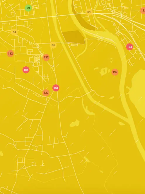
Real-time Lower Woods Trail Northeast, Bradley County air pollution map
Pollen
What is the pollen count in Lower Woods Trail Northeast today?
Index

High
Tree Low | 25% |
Grass Moderate | 50% |
Weed High | 75% |
Source:
wetter.comPollen
What is the pollen count in Lower Woods Trail Northeast today?
Index
High
Tree Low | 25% |
Grass Moderate | 50% |
Weed High | 75% |
Source:
wetter.comHistoric air quality near Lower Woods Trail Northeast
History
Historic air quality graph for Lower Woods Trail Northeast
Measure your own air quality
Get a monitor and contribute air quality data in your city.
Most polluted locations near Lower Woods Trail Northeast, Bradley County
Worldwide AQI⁺ rankingStation ranking
Real-time Lower Woods Trail Northeast AQI⁺ station ranking
City ranking


