
Hounslow Brentford, 伦敦附近的空气质量
Hounslow Brentford, 伦敦附近的空气质量指数(AQI⁺)和PM2.5空气污染 • 4.2K 关注者
没有当前数据最后更新 18:00, 6月 12日 当地时间
39
美国 AQI⁺优秀

主要污染物:
PM2.5
7 µg/m³
14°
11 km/h
74 %
每小时预报
Hounslow Brentford, 伦敦空气质量指数(AQI⁺)预报
每日预报
|
Hounslow Brentford, 伦敦空气质量指数(AQI⁺)预报
| 今天 | 27 | 21° 13° | 14 km/h | 53% | |
| 周日 | 23 | 20° 11° | 8 km/h | 59% | |
| 周一 | 34 | 21° 12° | 11 km/h | 63% |
空气污染物
Hounslow Brentford现在的空气质量如何?
当前 PM2.5 浓度是 WHO 年度 PM2.5 指导标准值的 1.4 倍
健康建议
尽情享受室外活动 |
请开窗以获取洁净新鲜的空气 了解空气质量监测仪 |

Hounslow Brentford附近空气质量历史数据
历史数据
Hounslow Brentford历史空气质量图表
39 美国 AQI⁺
优秀
18:00–19:00 6月12日 当地时间
美国 AQI⁺
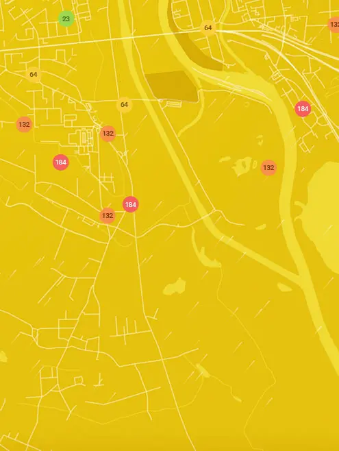
Hounslow Brentford, 伦敦附近污染最严重的地点
全球AQI⁺排名站点排名
实时Hounslow Brentford 监测站AQI⁺排名
获取Hounslow Brentford, 伦敦的全面空气质量数据


下载我们的空气质量应用程序
进一步了解全球空气质量


伦敦哪里空气最干净
- Lynton Road4
- 1-8 Dukes Point10
- Guildhall14
- Groombridge Road-LBHPA1a17
- London Marylebone Road20
- Cromwell Road22
- Donald Road22
- Newham22
- Offord Road Green Alliance22
- Stamford Street22
- Ealing John Perryn Primary School23
- London Bloomsbury24
- London N. Kensington24
- Haringey Wood Green26
- Plumstead High Street27
- Altab Ali Park28
- Connaught Village28
- Falcon Building, Bloomsbury28
- Falconwood28
- Hackney New Primary School28
- Imperial War Museum28
- LARA-east28
- London Westminster28
- Oakley St28
- Old Farm Ave Allotment28
- Porchester Road28
- Royal Street28
- Science Museum28
- Scotch House Corner - Westminster28
- Serpentine Gallery28
- Sloane Square28
- Whitfield Nursery Playground28
- Ealing Acton Background29
- London Farringdon Street31
- Tally Ho31
- HF 7 - Riverwalk32
- A1203 - Shadwell33
- AerosolScience 233
- Air on the Green33
- Ashmead School, SE833
- Barking Food Forest33
- Barnes Wetlands33
- Camden Kerbside33
- Columbia Road Primary School33
- Concert Hall Approach33
- Elsley Primary School33
- Green Westbourne33
- Gunthorpe St33
- HF 9 - Sands End33
- Hackney Amhurst Road33
- Harlesden High Street33
- Imperial College White City - Scale Space33
- John Harrison Way33
- Kew Gardens33
- Linden Children's Centre33
- London Honor Oak Park33
- Myatt’s Fields Park33
- Sloane Street33
- Southwark Elephant and Castle33
- Southwark South Circular Road33
- St Francis of Assisi33
- St Matthew's Road, Brixton33
- Sunny Hill, Hendon33
- Upper Ground33
- Warwick Road33
- Waterloo Place (The Crown Estate)33
- Waterloo Road33
- Wellington Square33
- Wentworth St33
- Wren Close33
- Southwark A2 Old Kent Road34
- Highgate West Hill Resident35
- LARA West35
- N6 6NA 235
- Regent Street (The Crown Estate)36
- Wormwood Scrubs37
- 101 Euston Road opposite British Library38
- Rosemead Preparatory School & Nursery38
- Cam Road39
- Cricklewood Lane39
- Elthorne Park & Leighton Roads Residents Association39
- Fiveways Sidcup Rd A2039
- Lancaster West RA39
- Mary Immaculate and St. Peter's Church39
- National Gallery39
- Tower Hamlets Roadside39
- Victoria Park Harriers39
- Westhorne Avenue (reference co-location)39
- Weymouth Avenue - Little Ealing Lane39
- Willesden High Street39
- N6 6NA42
- Belvedere44
- Greenwich Woolwich Flyover44
- Hammersmith Town Centre44
- Lavender Hill (Clapham Jct)44
- Blackheath50
- Bowes Primary School50
- Merton Road50
- Southwark Tower Bridge Road50
- Hackney Dalston Lane53
- Northumberland Place54
- Brent Ikea (reference co-location)55
- Hackney Old Street56
- Tooting High Street56
- A206 Burrage Grove57


