

每小时预报
City of Minneapolis Community Air Monitoring Project 14, 明尼阿波利斯空气质量指数(AQI⁺)预报
每日预报
|
City of Minneapolis Community Air Monitoring Project 14, 明尼阿波利斯空气质量指数(AQI⁺)预报
| 今天 | 15 | 23° 16° | 28 km/h | 59% | |
| 周日 | 14 | 21° 10° | 24 km/h | 47% | |
| 周一 | 15 | 25° 12° | 22 km/h | 43% |
空气污染物
City of Minneapolis Community Air Monitoring Project 14现在的空气质量如何?
当前 PM2.5 浓度符合 WHO 年度 PM2.5 指导标准。
健康建议
尽情享受室外活动 |
请开窗以获取洁净新鲜的空气 了解空气质量监测仪 |
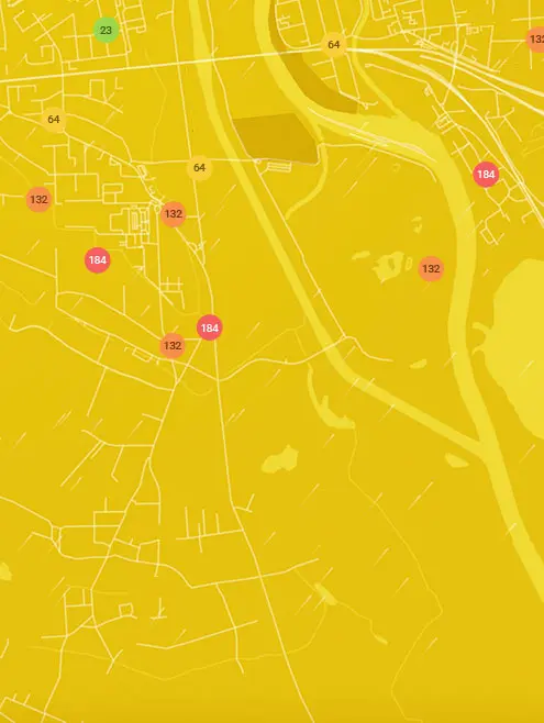
实时City of Minneapolis Community Air Monitoring Project 14, 明尼阿波利斯空气污染地图
花粉
今天City of Minneapolis Community Air Monitoring Project 14的花粉量是多少?
指数

中等
树木 低 | 25% |
青草 中等 | 50% |
杂草 中等 | 50% |
来源:
wetter.com花粉
今天City of Minneapolis Community Air Monitoring Project 14的花粉量是多少?
指数
中等
树木 低 | 25% |
青草 中等 | 50% |
杂草 中等 | 50% |
来源:
wetter.comCity of Minneapolis Community Air Monitoring Project 14附近空气质量历史数据
历史数据
City of Minneapolis Community Air Monitoring Project 14历史空气质量图表
15 美国 AQI⁺
优秀
07:00–08:00 6月13日 当地时间
美国 AQI⁺
City of Minneapolis Community Air Monitoring Project 14, 明尼阿波利斯附近污染最严重的地点
全球AQI⁺排名站点排名
实时City of Minneapolis Community Air Monitoring Project 14 监测站AQI⁺排名
获取City of Minneapolis Community Air Monitoring Project 14, 明尼阿波利斯的全面空气质量数据


下载我们的空气质量应用程序
进一步了解全球空气质量


明尼阿波利斯哪里空气最干净
- Alie Micka2
- Minnehaha Creek/Lake Harriet2
- Bancroft3
- Windom3
- East Isles6
- Elliot Park6
- 2193-2197 E 58th St8
- 2nd St NE & 23rd Ave NE8
- W Minnehaha Pkwy8
- 2299-2201 N 43rd Ave9
- 2399-2305 Irving Ave S9
- Harrison9
- 1216-1294 Lakeview Ave S10
- 1800-1820 Franklin Ave SE10
- 2199-2183 Douglas Ave10
- City of Minneapolis Community Air Monitoring Project 910
- 104 E 56th St11
- 12th Avenue11
- 1801-1809 E 27th St11
- 3501-3507 E 45th St11
- 3758 Emerson Ave N11
- 5100-5198 16th Ave S11
- City of Minneapolis Community Air Monitoring Project 711
- City of Minneapolis Community Air Monitoring Project 7711
- City of Minneapolis community air monitoring project 3311
- Logan Park11
- 12 E 55th St12
- 1264-1322 23rd Ave NE12
- 1299-1251 N 29th Ave12
- 2798-2700 E 22nd St12
- 46th St E & 3rd Ave S12
- 5159 N Humboldt Ave12
- City of Minneapolis Community Air Monitoring Project 2012
- Minnehaha12
- Seward-Franklin12
- 1211-1153 29th Ave NE13
- 1299-1251 W 27th St13
- 2522 County Rd 2313
- 2600-2698 36th Ave N13
- 550-598 W 27th St13
- 910-900 E 32nd St13
- 1026-1032 27th Ave SE14
- 1500 7th St. S14
- 2301-2343 E 41st St14
- 3301-3345 E 36th St14
- 5050-5086 47th Ave S14
- 5399-5301 Pleasant Ave14
- 3100-3198 29th Ave S15
- 4928 38th Ave S15
- City of Minneapolis Community Air Monitoring Project 1415
- Columbia Park (Backyard)15
- 241-223 St Albans St N16
- 699-649 W 41st St16
- 98-70 8th Ave NE16
- Chowen Triangle Station16
- 164-198 1st Ave NE17
- 1699-1601 10th Ave S17
- 26th Ave NE17
- 3699-3651 W 53rd St17
- 462-440 Central Ave W17
- 4858 Dupont Ave N17
- 610 W 29th St17
- 2650-2698 N 16th Ave18
- Logan Park 218
- Minneapolis - Anders18
- Minneapolis - East P18
- Linden Hills19
- Minneapolis - Lowry 19
- Minneapolis - Near R19
- Ventura Village19
- Minneapolis - Pacifi20
- NE 36th Ave20
- 36ish & Hiawatha21
- I-35W at Mississippi River22
- Minneapolis - Bottin22


